Tourist Attraction


Located on the seashore, this structure is one of the main buildings of the Tulum archaeological site. El Castillo (The Castle) was built by the ancient Mayas on a cliff, 12 meters (40 feet) above sea level, which makes it a strategic surveillance point for preventing possible attacks by enemies, as well as to guide Maya seafarers at risk of crashing into the coral reef located near Tulums coast, which is part of the Mesoamerican reef system. This system is considered to be the second large
Follow in the footsteps of ancestral cultures When people talk about San Miguel de Allende, your mind immediately wanders to galleries, boutique hotels, cobblestone streets, and the mojigangas (enormous papier-mâché puppets) that enliven the callejoneadas (walking serenades through the city streets, led by traditional musical groups). However, it rarely occurs to anyone that they might also find archaeological sites there. The Cañada de la Virgen (The Virgins Glen), an ancient astronomical obser
A tour of the Xpujil Archaeological Zone will take you on a journey back in time when the ancient Maya inhabited this area 400 B.C., located in the Calakmul Biosphere Reserve and a few kilometers from the border with Belize.Your first impression of Xpujil is likely to be of Building 1, a construction that stands out from the remains with three towers. If you get close, you will see that inside it there were 12 rooms with some passages and tunnels to interconnect them. Its rounded and stoic corne
The Historic Center of Palizada is surrounded by three parks: Benito Juarez, La Madre (Mothers) and Parque Libertad (Liberty Park) which owes its name to the fact that it has a replica of the famous Statue of Liberty in New York, USA. Around Benito Juarez Park, Palizadas main park, youll find shops and restaurants to enjoy traditional dishes such as pochitoque en verde, hicotea en estofado, mondongo, pejelagarto empanadas and frijol con puerco. Dont forget to try the ice creams made with na
Edzná Archaeological Site also has a small on-site museum located near the entrance, where it is possible to start the imaginary journey to the times of splendor of this mythical Mayan city.The site exhibits some of the 33 stelae recovered during the excavations, in addition to face figures of the ten identified rulers -including a woman- of the city and different pieces that refer to celebrations and rituals carried out in the place.
A good example of Puuc architecture (derived from the earliest style of construction known as Petén) of Edzná is the Plataforma de los Cuchillos (Platform of the Knives), located in the northern part of the archaeological site.An offering of flint knives found in that place inspired the name by which this structure is currently known, which was accessed by stairways located on its four sides.The building had 20 rooms, of which 12 had vaulted ceilings that have not been preserved and eight more w
Towards the southern side of the archaeological site, next to the Small Acropolis, is another of the most interesting corners of Edzná: the Templo de los Mascarones (Temple of the Masks), which has two representations of the solar deity Kinich Ahau, at dawn and dusk, modelled in stucco.The faces have human features and attributes associated with the ruling elites, such as squint eyes, nose rings and earmuffs, mutilated teeth and zoomorphic headdresses.On one side of the masks stands the Small Ac
Next to Edznás main square is the building called Nohochná or Casa Grande, which is 135 meters ( 394 feet) long.Archaeologists estimate that this large structure, which has four galleries at the top supported by pilasters, may have served to carry out administrative functions, although it is also thought that its stands may have been a preferential place to witness the events that took place in the Main Square.
Most of Edznás buildings that were restored are located around the Main Square.On one side is the Great Acropolis, a quadrangular space where the most emblematic and beautiful building of the archaeological site stands: the Pirámide de los Cinco Pisos (Five Floor Pyramid), so called because it has five staggered levels with entrances that lead to vaulted rooms and a temple on top.In front of this great structure is the Solar Platform, used by the Mayans who inhabited the place to observe astrolo
A must-see when walking down the streets of the downtown of San José del Cabo are the art galleries located along calle Álvaro Obregón, such as: Galería Logan, a site dedicated to Huichol art; and Galería de Arte Contemporáneo Pez Gordo, a classic art gallery that exhibits contemporary paintings and pictures that reflect the artistic talent of the region. Due to the proximity between its galleries, this area is also known as Art Walk, which also opens its doors to restaurants and bars where
With a colorful facade, the Casa de la Cultura Profesor Alfredo Green González in San José del Cabo invites you to get to know its history and facilities. The enclosure opened its doors in 1974, with the Biblioteca Pública Municipal (“Municipal Public Library”) as a shelter. Historical records indicate that the building was inhabited by Missionary Priests of the Añuití, today San José Mission. In the place, the heritage of the historical legacy and the tradition of continuing to strengthen
On the road to Vallecitos km 1, in Ejido Jacume, in Tecate, Baja California, is El Vallecito Archaeological Zone, a site where you can see cave paintings whose regional style is currently called Diegueño Representacional. By means of a tourist footpath it makes a route of approximately two kilometers (1.5 miles) and observes five shelters with cave paintings. The area is made up of a great variety of archaeological sites, where you can explore isolated materials, open-air housing camps
More than 10,000 years ago, Baja California was inhabited by hunting, gathering and farming tribes such as the Kumiai. They settled from the town of Santo Tomás to the coast of San Diego, in California. As a legacy of their passage through Mexican lands, they left a set of 18 cave paintings that make up the archaeological site El Vallecito, located in La Rumorosa.The site is still bordered by pine forests that were exploited by the Kumiai Indians in summer. The fruit was considered sacred for th
Below la Parroquia de Nuestra Señora de Belén (the Parish Church of Our Lady of Belen), there are three underground tunnels that reach about 60 meters in length. In these tunnels, there are some wells with water that today visitors have adopted as “wishing wells” and throw coins inside, as well as human remains in urns distributed throughout the place. Another interesting space in the same enclosure is the Pinacoteca de Asientos that treasures jewels such as altarpieces and canvases from th
Located 30 minutes (15 km/9 miles) from downtown Comitán, is the Zona Arqueológica Tenam Puente (Tenam Bridge Archeological Zone), which originally sat on a hill that was modified to create a series of terraces on which you can see buildings, squares and courts of the ball game. Its strategic location, on the route that communicates the Altos de Chiapas and Guatemala, favored the zone to have access to commercial networks of great importance, something that can be appreciated
Ancient and sacred foundationsTzintzuntzan, “lugar de colibríes” (place of hummingbirds), takes its name from the Purépecha language and historians say that it became so powerful that even the Aztecs tried to subdue it without success. Its glorious past remains alive in Zona Arqueológica y Museo Las Yácatas (Las Yácatas Archaeological Zone and Museum), which you will see rising above a plain with its rectangular and circular shapes. This place,
The representation of Izamal According to historians, Izamal maintained magnificent connections with all cities, by means of the sacbés or “white roads” that allowed the city to have control of the territory of more than six thousand square meters in the north of the peninsula. This happened during the Preclassic period - about 2,700 years ago. Even then, Izamal already had a whole community planned, with its pyramids and buildings that refused to disappear, such as
The Mayan treasure of ChiapasEight kilometers (5 miles) from this Pueblo Mágico (Magical Town) is the Zona Arqueológica de Palenque (Palenque Archaeological Zone), one of Mayan culture most important, it was recognized as a World Heritage Site by UNESCO in 1987. Although the area that we can visit is only a small percentage of what Palenque really was during its splendor in the Classic period, the Templo del Conde (Temple of the Count), El Palacio (The Palace) and the Templo d
The house of thunder in PapantlaThe word “tajin” has been translated as “thunder” or “great smoke”, so this Mesoamerican religious and political center is often referred to as “casa del trueno” (house of thunder). How to get to El Tajin Archeological zone?The El Tajín archaeological zone is located just 10 kilometers (16 miles) from Papantla and in 1992 it was declared a World Heritage Site by UNESCO, given its archaeological, cultural,
Eternal footprints of great civilizations The vestiges of this archeological zone are hidden in the jungle, just half an hour from Valladolid. Its splendour lies in its steles, ramparts and sumptuous palaces that were built in the Pre Classical period, before the arrival of the Spanish Conquistadors. Ek Balam is an example of how the Mayan population was connected with other cities through its sacbés, white sand roads that shine in the dark. Precisely, these roads are the ones that wil
 Ian Schrager's Hotel Secrets: Crafting Iconic Hotspots
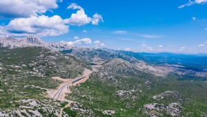 Breathtaking Winding Road Through Untamed Wilderness Landscape
 Beijing's Must-Try Foods: Iconic Dishes from Peking Duck to Spicy Crayfish
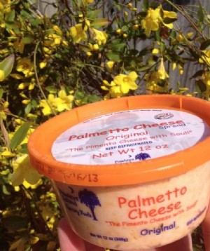 Palmetto Cheese: South Carolina's Award-Winning Pimento Cheese Staple
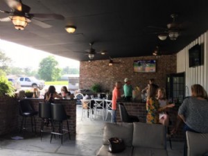 Bodega Wine Dive: A Must-Visit Wine Haven Worth the Trip from Lake Charles
 5 Must-Do Activities for an Unforgettable Santa Fe Thanksgiving Weekend