Top 10 Epic 2-3 Day Backpacking Trips on Virginia's Appalachian Trail
The Appalachian Trail spans over 550 miles through Virginia's stunning mountains, weaving through diverse public lands like George Washington and Jefferson National Forests, Shenandoah National Park, and Blue Ridge Parkway areas. As the backbone of an expansive trail network covering thousands of miles, it unlocks endless backpacking opportunities in the Old Dominion.
Leveraging the AT and its connectors, these curated 2-3 day adventures deliver immersive experiences: vast woodlands, pristine wilderness, old-growth forests, waterfalls, overlooks, and a touch of Virginia history.
Pack your gear and embark on these rewarding highland escapes along the AT.
APPALACHIAN TRAIL: VIRGINIA CREEPER LOOP
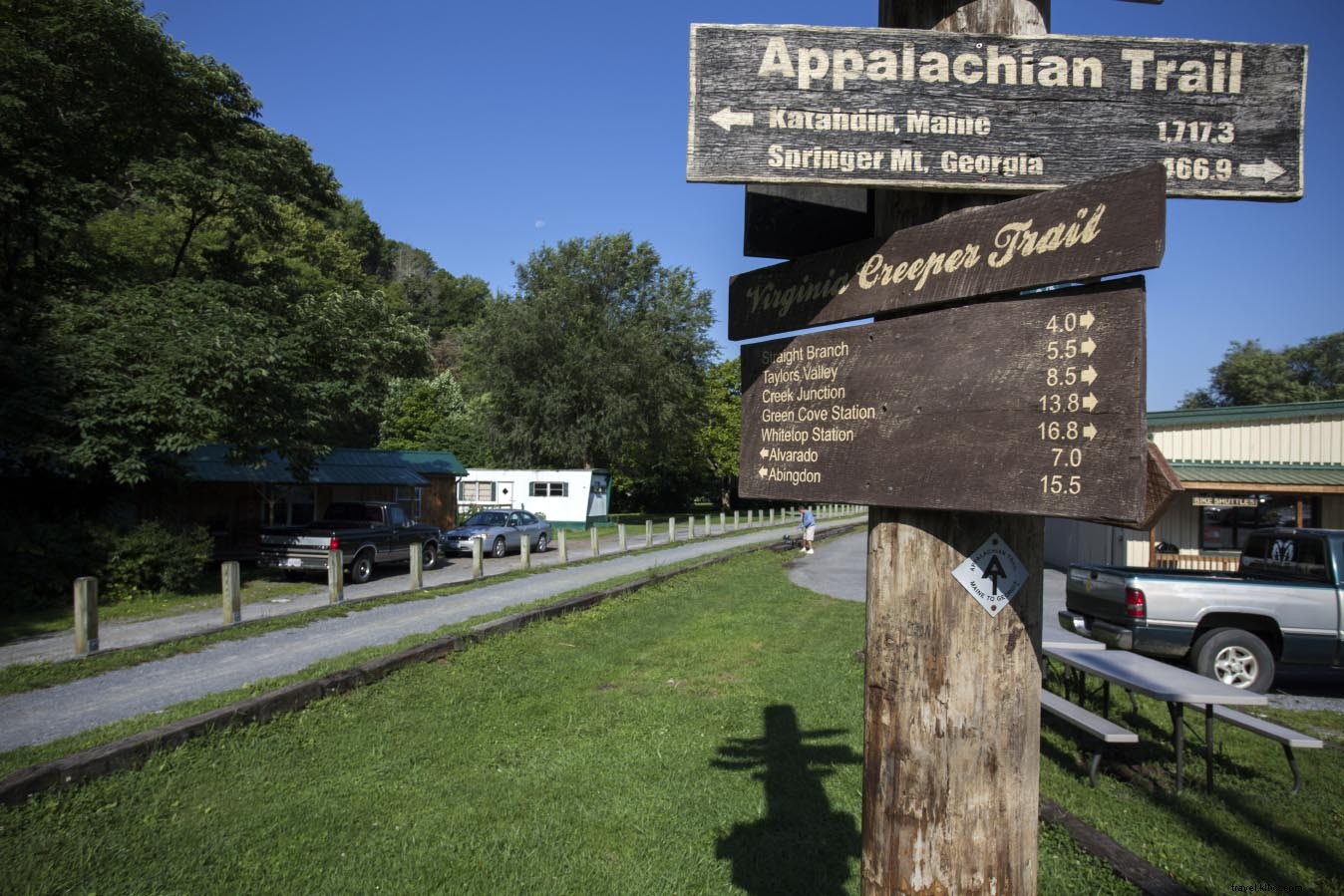
Nearest Town: Damascus
Distance: 13.8-mile loop
Elevation: 2,190 ft low, 3,410 ft high
GPS Trailhead: N36° 38.645′, W81° 44.407′
Highlights: Historic rail trail, streams, shelter, partial views
Overview:
This engaging loop in Mount Rogers National Recreation Area follows the scenic Whitetop Laurel Creek Valley along the renowned Virginia Creeper Trail. A gentle ascent connects to the Appalachian Trail, climbing to Straight Mountain's crest for partial vistas, Saunders Shelter, and additional camping. Return via the AT with scenic switchbacks.
Camping: Abundant sites along the Virginia Creeper Trail; Saunders Shelter and tent spots on the AT.
Key Notes: Expect fellow hikers, backpackers, and cyclists on the Creeper Trail—not ideal for solitude seekers.
Nearby Attractions:
- Mount Rogers Outfitters
- Virginia Creeper Trail
- Old Mill Restaurant
- Barter Theater
APPALACHIAN TRAIL: ELK GARDEN TO FOX CREEK
Nearest Town: Troutdale
Distance: 17.0-mile point-to-point
Elevation: 3,400 ft low, 5,240 ft high
GPS Trailhead: Start: N36° 38.767′, W81° 34.984′ | End: N36° 41.85′, W81° 30.26′
Highlights: Two wilderness areas, panoramic high country views, wild ponies
Overview:
Virginia's highest AT section in Mount Rogers National Recreation Area offers nonstop vistas through spruce-fir forests near Mount Rogers, Virginia's tallest peak. Rock outcrops overlook meadows with wild ponies and summer blueberries; includes Grayson Highlands State Park.
Camping: Three shelters or dispersed wooded sites.
Key Notes: Prepare for wind, fog, rain, and cold in this exposed high country.
Nearby Attractions:
- Park Place Drive-in
- Virginia Creeper Trail
- Hungry Mother State Park
- Grayson Highlands State Park
APPALACHIAN TRAIL: FALLS OF DISMAL TO NEW RIVER
Nearest Town: Pearisburg
Distance: 22.0-mile point-to-point
Elevation: 1,620 ft low, 4,000 ft high
GPS Trailhead: Start: N37° 11.259′, W80° 54.058′ | End: N37° 19.757′, W80° 45.063′
Highlights: Stream hiking, ridge views, less-traveled section
Overview:
Begin at picturesque Dismal Falls, then follow the AT northbound along Dismal Branch for rare streamside hiking. Ascend Flat Top Mountain near 4,000 ft, ridge-run to Pearis Mountain's Angels Rest overlook of New River Valley, and descend to the river.
Camping: Two shelters, Dismal Creek sites, ridge springs.
Key Notes: Reliable water from springs and creeks.
Nearby Attractions:
- New River canoeing, kayaking, fishing
- Nicholas R. Anderson Observatory
- Mountain biking at Pandapas Pond
- Cascade Falls
APPALACHIAN TRAIL: ROANOKE TRIPLE CROWN
Nearest Town: Roanoke
Distance: 28.0-mile point-to-point
Elevation: 1,460 ft low, 3,190 ft high
GPS Trailhead: Start: N37° 22.716′, W80° 9.370′ | End: N37° 23.471′, W79° 54.392′
Highlights: Iconic viewpoints—Dragons Tooth, McAfee Knob, Tinker Cliffs—plus Hay Rock
Overview:
This premier route hits Western Virginia's top AT vistas: scramble to 360° Dragons Tooth, iconic McAfee Knob, expansive Tinker Cliffs, and angular Hay Rock. Circles Carvins Cove Reservoir; ends near I-81 at Daleville.
Camping: Four shelters plus ridge sites.
Key Notes: Crowds at popular knobs; expect company.
Nearby Attractions:
- Local Roots – Farm-to-Table Restaurant
- Read Mountain Preserve
- Roanoke Star on Mill Mountain
- Paddle Roanoke River
THUNDER RIDGE TO JAMES RIVER FACE WILDERNESS
Nearest Town: Glasgow
Distance: 17.3-mile point-to-point
Elevation: 678 ft low, 4,225 ft high
GPS Trailhead: Start: N37° 30.458′, W79° 31.409′ | End: N37° 36.299′, W79° 23.345′
Highlights: Extreme elevation change, The Guillotine, two wildernesses, James River Bridge
Overview:
From Blue Ridge Parkway, traverse Thunder Ridge Wilderness over Apple Orchard Mountain (highest AT point until New Hampshire), under The Guillotine, into James River Face Wilderness. Descend Matts Creek to the river's hiker bridge.
Camping: Thunder Hill and Matts Creek shelters; Marble Spring and creek sites.
Key Notes: Over 3,500 ft elevation change—pack for variable weather.
Nearby Attractions:
- Otter Creek Recreation Area
- Natural Bridge of Virginia
- Scottos Pizza
- Paddle James River
MOUNT PLEASANT SCENIC AREA
Nearest Town: Buena Vista
Distance: 11.5-mile figure-eight loop
Elevation: 3,110 ft low, 4,030 ft high
GPS Trailhead: N37° 45.581′, W79° 11.730′
Highlights: Meadow vistas, fields, quality campsites, half-loop option
Overview:
Panoramic Blue Ridge loop mixes woods and fields: AT to Cole Mountain meadows, Old Hotel Trail, optional Henry Lanum to Mount Pleasant's dual summits, ridge to Pompey Mountain.
Camping: Cowcamp Gap shelter, Little Cove Creek, ridgetop near Mount Pleasant.
Key Notes: Spur trail spring for ridgetop sites.
Nearby Attractions:
- Hulls Drive-in
- Virginia Military Institute
- Glen Maury Park
- Original Italian Pizza
THREE RIDGES WILDERNESS LOOP
Nearest Town: Amherst
Distance: 14.5-mile loop
Elevation: 1,660 ft low, 3,940 ft high
GPS Trailhead: N37° 54.101′, W78° 59.113′
Highlights: Wilderness panoramas, streams, Campbell Creek Falls
Overview:
In Three Ridges Wilderness, AT delivers ridge views and Chimney Rock; descends to Harpers Creek, Mau-Har Trail to 50-ft Campbell Creek Falls and cascades.
Camping: AT shelter and sites; Campbell Creek streamside.
Key Notes: Short but strenuous with ups/downs.
Nearby Attractions:
- Luminhaus B&B
- The Briar Patch Restaurant
- James River State Park
- Rockcliffe Farm Retreat
APPALACHIAN TRAIL: MOORMANS RIVER LOOP
Nearest Town: Charlottesville
Distance: 18.1-mile loop
Elevation: 1,130 ft low, 3,110 ft high
GPS Trailhead: N38° 9.174′, W78° 46.366′
Highlights: Views, waterfalls, swimming holes, trout fishing, historic sites
Overview:
Southern Shenandoah NP loop: AT crest views to Moormans River valleys, Big Branch Falls, deep pools; return via rocky spine. Prime for fishing/swimming in season.
Camping: Stream valley sites; backcountry permit required.
Key Notes: Multiple river crossings—use poles.
Nearby Attractions:
- Continental Divide Restaurant
- Monticello Wine Tour and Coach Company
- Sherando Lake Recreation Area
- Humpback Rocks Visitor Center
BEARFENCE MOUNTAIN: CONWAY RIVER LOOP
Nearest Town: Elkton
Distance: 12.0-mile loop
Elevation: 1,210 ft low, 3,440 ft high
GPS Trailhead: N38° 28.068′, W78° 27.445′
Highlights: Waterfalls, vistas, Bearfence Rock Scramble
Overview:
Thrilling loop: Conway River, Slaughter Trail pioneer site, AT to Bearfence scramble (backpack-friendly), epic 360° views including park landmarks; AT return.
Camping: Conway River, upper Devils Ditch, Bearfence Hut.
Key Notes: Park/WMA permit advised.
Nearby Attractions:
- Ciro’s Italian Eatery
- Paddle Shenandoah River
- South River Falls
APPALACHIAN TRAIL: THORNTON HOLLOW LOOP
Nearest Town: Sperryville/Luray
Distance: 15.4-mile loop
Elevation: 1,440 ft low, 2,960 ft high
GPS Trailhead: N38° 43.439′, W78° 19.198′
Highlights: Park-caliber scenery, historic homesites, scenic river, views
Overview:
Shenandoah NP North District: Thornton Hollow history, North Fork camping, Hull School Trail, Bolen Cemetery, Keyser Run to Piney River headwaters, AT finish. Ideal for anglers/history lovers.
Camping: Thornton/Piney Rivers; permit required.
Key Notes: Four Thornton crossings—rock hops in summer, caution post-rain.
Nearby Attractions:
- Luray Caverns
- Big Meadows Lodge
- Victorian Inn
- Paddle/fish South Fork Shenandoah River