Death Valley National Park: Ultimate Guide to Highlights, Hikes, and Visitor Tips

Death Valley's name suggests a brutal, scorching inferno—a barren wasteland of biblical proportions. Yet, a closer look reveals nature's dramatic spectacle: sweeping sand dunes, water-carved canyons, mysterious sailing rocks, ancient volcanic craters, palm-fringed oases, jagged peaks soaring to 11,000 feet, and thriving endemic wildlife.
This land of extremes claims U.S. records: the hottest temperature ever (134°F/57°C), the lowest point (Badwater Basin at 282 feet below sea level), and the largest national park outside Alaska (over 5,300 square miles).

Does Anyone Live in Death Valley?
The Timbisha Shoshone have inhabited the Panamint Range for centuries, wintering in the valley to harvest acorns, hunt waterfowl, catch pupfish, and grow corn, squash, and beans. After the 1933 creation of Death Valley National Monument, the tribe faced relocations, eventually settling on a 40-acre site near Furnace Creek, where they reside today.
In 2000, President Clinton returned 7,500 acres to the Timbisha Shoshone, establishing the first Native American reservation within a U.S. national park. Visit their Indian Village near Furnace Creek and try the hearty Timbisha Taco ($10–$12), featuring fry bread instead of a tortilla.

Top Highlights in Death Valley National Park
Zabriskie Point
Visit at dawn for breathtaking vistas over golden badlands eroded into surreal waves and folds. Named for a Pacific Coast Borax Company manager, it starred in Michelangelo Antonioni's 1970 film and inspired U2's Joshua Tree album cover.
Mesquite Flat Sand Dunes
These accessible dunes rise up to 100 feet near Stovepipe Wells. Capture their magic at sunrise or sunset, with long shadows highlighting footprints. On full-moon nights, they're enchanting; listen closely for a faint humming from the crest.

Badwater Basin
North America's lowest point (282 feet below sea level) features vast, wrinkled salt flats. A boardwalk leads over evaporating, mineral-rich pools—an otherworldly sight, 17 miles south of Furnace Creek.
Dante's View
A winding road climbs to 5,475 feet for panoramic views of the basin. On clear days, spot Mt. Whitney (highest) and Badwater (lowest) in the contiguous U.S. Allow 1½ hours for the 26-mile round trip from Hwy 190.

Amargosa Opera House
Dancer Marta Beckett transformed a 1920s adobe in Death Valley Junction into a stage for her shows until 2017. Performers continue her legacy in fall and winter. A roadside memorial honors her pioneering spirit.
Artists Drive
This 9-mile scenic route south of Furnace Creek dazzles with twists and dips. Stop at Artists Palette, where mineral oxidation paints hills in vibrant rose, green, and purple—stunning pre-sunset.

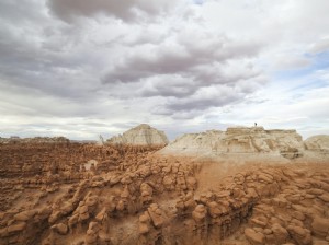
Racetrack Playa
A rough 27-mile dirt road (high-clearance 4WD advised) leads to this dry lakebed, where rocks leave trails. Scientists solved the mystery in 2014: thin ice sheets pushed by wind. Learn more at www.racetrackplaya.org.
Rhyolite
This ghost town captures the gold rush boom-bust: from 8,000 residents in 1908 to ruins today. Explore the school, bank, and a house built from beer bottles.

Death Valley Weather Essentials
Sunny and dry year-round, but temperatures swing from 38°F/3°C in December to 116°F/43°C in July. Layer up and plan accordingly.
Visit in winter or spring wildflower season. Summers demand air-conditioned vehicles and limit valley hikes to dawn/dusk; head to mountains for relief. Watch for winter rains causing flash floods or snow closures.

Best Hiking Trails
Prime hiking season: November–March. Avoid summer valley trails; higher mountains may be snowy in winter. Trails often require scrambling; carry ample water (1 gallon/person/day in summer, ½ in winter).
Golden Canyon
Explore golden walls via a 3-mile out-and-back to Red Cathedral or extend with Gower Gulch Loop (4 miles total). Start from Badwater Rd or Zabriskie Point for Badlands Loop (2.7 miles).

Mosaic Canyon Trail
A 4-mile round trip from a gravel road end west of Stovepipe Wells features polished marble walls. Narrow slots and a boulder scramble add adventure.
Telescope Peak
Park's highest point (11,049 feet) via 14-mile trail with 3,000-foot gain from Mahogany Flat. Winter needs ice axe/crampons; snow-free by June. Views rival the Grand Canyon's depth.
Wildrose Peak
8.4-mile round trip (2,200-foot gain) through piñon and juniper to 9,064 feet. Epic panoramas halfway; toughest near summit. Ideal spring/fall.

Planning Your Death Valley Visit
$30 vehicle entry (7 days) available at pay stations or visitor center. Cell service limited to Furnace Creek/Stovepipe Wells.
Main roads paved; dirt routes need high-clearance/4WD, especially post-rain. Check visitor center for conditions.

Furnace Creek
Main hub with visitor center, gas, ATM, lodging, dining, and store. Stovepipe Wells and Panamint Springs offer similar services. Gas pricey and 24/7 at Furnace Creek/Stovepipe.
Beatty
40 miles north in Nevada: budget base with gas, ATM, and store for Death Valley trips.

Shoshone
60 miles south: gas, store, dining, lodging for southern access.
Tecopa
70 miles south: hot springs, breweries, eateries, and palm oasis in a quirky mining town.

Death Valley Hotels and Lodging
In-park options limited/pricey; book ahead for spring. Nearby: Beatty (40 miles), Lone Pine (40), Death Valley Junction (30), Shoshone (60), Tecopa (70), Ridgecrest (120), Las Vegas (140).
The Oasis at Death Valley
Iconic 1927 Spanish Mission-style resort with modern comforts, spring-fed pool, spa, lounge, and sweeping desert views.
The Amargosa Hotel
Vintage 1925 lodge next to the Opera House: no TV/Wi-Fi, but murals, ghosts, and starry skies. New mattresses; shared kitchen; farm-to-table café nearby.

Camping in and Near Death Valley
Nine NPS campgrounds (Furnace Creek reservable Oct–Apr; others first-come). Sunset best for last-minute spots; backcountry free (1 mile from roads, no fires).
Get permits/regulations at visitor center. Private RV sites at Furnace Creek/Stovepipe/Panamint. Mesquite Springs and Thorndike popular.