10 Easy Beginner Hiking Trails in Virginia for Families with Kids
In today's fast-paced world, carving out quality family time is essential. An easy family hike offers the perfect opportunity to bond, explore nature, and stay active. Virginia boasts diverse, beginner-friendly trails—from coastal shorelines and waterfalls to panoramic overlooks—ideal for creating lasting memories with kids.
Discover simple joys like spotting insects, gathering colorful autumn leaves, or enjoying a picnic under a clear blue sky. These moments build strong family ties. Below, explore 10 accessible hikes across Virginia's stunning landscapes, selected for their family appeal, moderate distances, and rewarding features.
LEWIS SPRING FALLS LOOP
Nearest Town: Luray
Hike Distance: 3.3-mile loop
Why Go There: Mountaintop overlooks and waterfalls
What You Need to Know: Starts in the amenity-rich Big Meadows area of Shenandoah National Park
GPS Coordinates: 38.51636, -78.44363
Capture stunning views with your smartphone on this elevated trail. Begin on the renowned Appalachian Trail, ascending to the rocky Blackrock Summit for geological wonders and vistas. Continue past unique rock formations to the Lewis Falls Trail, culminating at the dramatic 81-foot Lewis Spring Falls—one of Shenandoah's highest-elevation waterfalls. A guardrail leads to a safe observation point overlooking the cascading water.
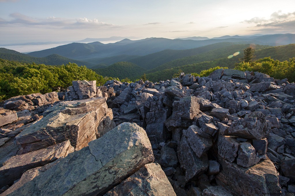 Blackrock Summit
The moderate elevation changes make it manageable for families.
After the Hike: Explore Big Meadows' lodge, visitor center, ranger station, picnic areas, and campground. Enjoy guided horseback rides at nearby Skyland along Skyline Drive.
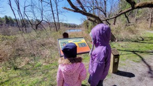
THREE LAKES PARK
Nearest Town: Henrico
Hike Distance: 1.3-mile triple loop
Why Go There: Scenic walks along three picturesque lakes
What You Need to Know: Features a nature center with a 50,000-gallon freshwater aquarium
GPS Coordinates: 37.61817, -77.4309
Pair this short trek with the impressive nature center overlooking the middle lake, showcasing local flora, fauna, and aquatic life. Follow easy, level paths circling Lake 1 (with picnic shelter and fishing pier), shallow Lake 2 (amphibian habitat), and Lake 3 (with angler-favored peninsula). Spot birds amid shaded trails lined with pine, birch, cedar, sweetgum, and oaks. Relax on the nature center's waterfront deck post-hike.
After the Hike: Visit Meadow Farm Museum, a living history site recreating an 1860s farm with animal tours and demonstrations.
RIVERBEND PARK
Nearest Town: Great Falls
Hike Distance: 2-mile loop
Why Go There: 10 miles of well-marked trails
What You Need to Know: Start at the visitor center for maps and park history
GPS Coordinates: 39.01763, -77.25543
This family-friendly park offers rolling paths through rocky vales and wooded ridges. Begin at the visitor center on Madison’s Escape Trail (honoring President James Madison's 1814 flight route), then connect to Follow the Hollows Trail. Detour to the nature center if desired, then reach the Potomac Heritage Trail along the river. Rent kayaks or canoes, picnic at Witch Hazel Bluff, or enjoy river views.
 Photo Credit: Mark Mackoviak
After the Hike: Head to nearby Great Falls Park for Potomac River overlooks, canal ruins, and more trails.
NORTHWEST RIVER PARK
Nearest Town: Chesapeake
Hike Distance: 4-mile loop
Why Go There: 8 miles of trails along undeveloped coastal waterways
What You Need to Know: Amenities include campground, cabins, canoe/paddleboat rentals, and biking
GPS Coordinates: 36.58611, -76.15264
Bridges span creeks feeding Northwest River and Smith Creek. From the ranger station, follow Indian Creek Trail to Deer Island Trail for river overlooks and fishing piers amid cypress. Continue via Otter Point Trail to Smith Creek, then Molly Mitchell Trail back (with six more bridges). Rent watercraft afterward.
After the Hike: Bike the flat Great Dismal Swamp Trail nearby.
EASTERN SHORE OF VIRGINIA NATIONAL WILDLIFE REFUGE
Nearest Town: Kiptopeke
Hike Distance: 2 miles out-and-back, plus optional 2.6 miles
Why Go There: Key migration stop for raptors, waterfowl, and butterflies (400+ bird species)
What You Need to Know: Visitor center offers seasonal programs and displays
GPS Coordinates: 37.12908, -75.96201
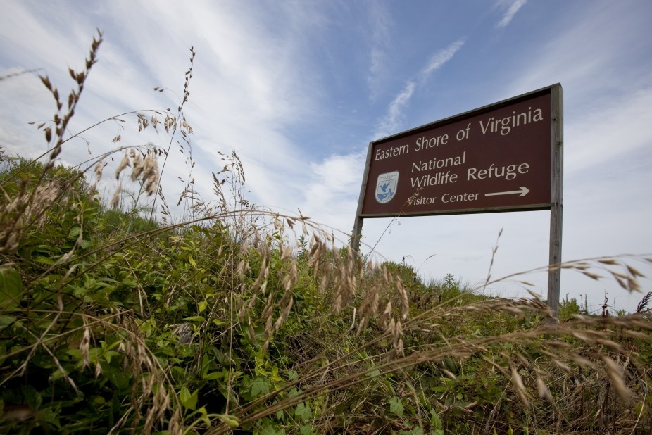 Photo Credit: Bill Crabtree, Jr.
From the visitor center, follow Butterfly Trail (with wildlife info) to Wildlife Trail through woods, past a historic cemetery, to salt marsh overlooks and WWII gun emplacements at former Fort John Custis. Backtrack or add the paved 2.6-mile Southern Tip Hike & Bike Trail.
After the Hike: Visit Eastern Shore Visitor Center or dine at The Jackspot in Cape Charles.
JOHNSON FARM AND ABBOTT LAKE
Nearest Town: Bedford
Hike Distance: 3.2-mile double loop
Why Go There: Historic farm and scenic mountaintop lake
What You Need to Know: Farmhouse staffed weekends/holidays
GPS Coordinates: 37.44563, -79.60997
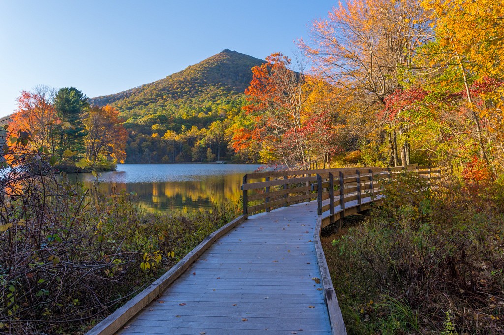 Photo Credit: Nicholas Moore
In Peaks of Otter along Blue Ridge Parkway, start at the 2,500-ft visitor center. Loop through woods to preserved Johnson Farm (homestead and outbuildings), then circle Abbott Lake amid peaks and lodge. Visit a 1830s log structure.
After the Hike: Enjoy Peaks of Otter amenities; tram to Flat Top for panoramas.
SMITH MOUNTAIN LAKE COMMUNITY PARK
Nearest Town: Moneta
Hike Distance: 1.9-mile loop
Why Go There: Peninsula loop with 360-degree lake views
What You Need to Know: Franklin County park with fishing pier, picnic areas, swim beach
GPS Coordinates: 37.08903, -79.61687
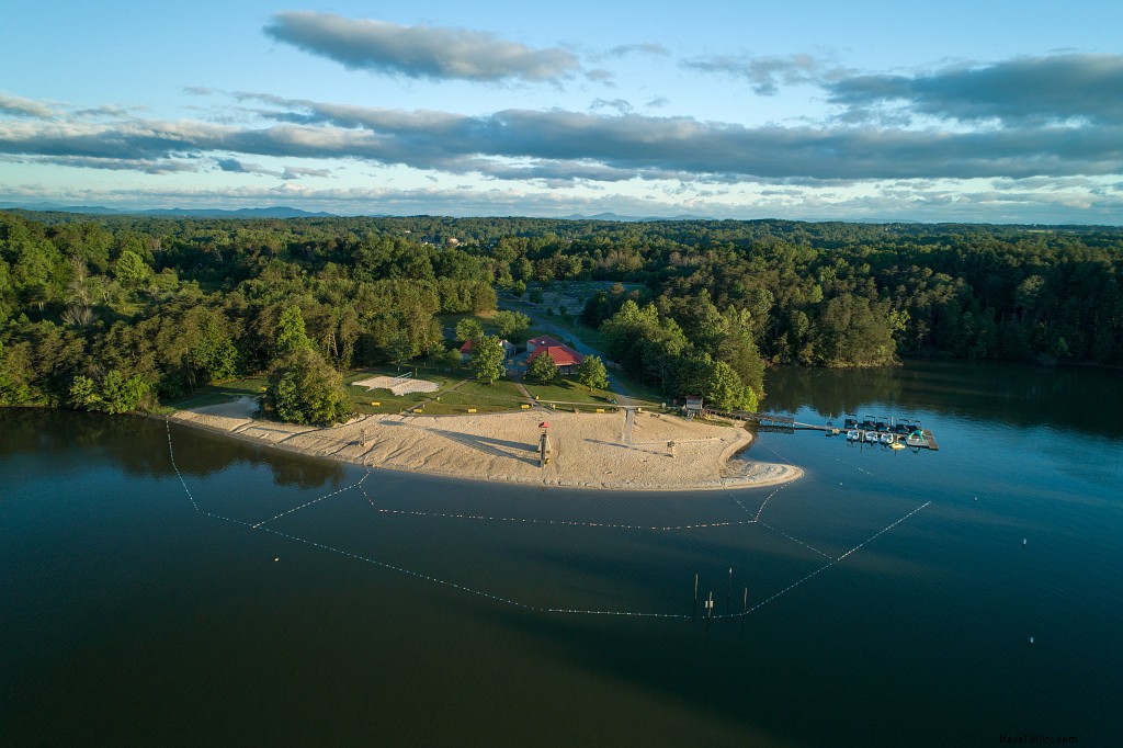 Photo Credit: Chad Williams, IG account: @echadwilliams
On a lake peninsula, the level trail hugs 600+ miles of shoreline via pea gravel paths through Piedmont woods (maple, pine, beech, oak). Views abound; visit fishing pier.
After the Hike: Base at Smith Mountain Lake State Park for camping, cabins, trails.
STAUNTON RIVER STATE PARK
Nearest Town: South Boston
Hike Distance: 3-mile loop
Why Go There: Shoreline loop at Dan and Staunton Rivers' confluence (Lake Kerr)
What You Need to Know: State park with fishing pier, picnic areas; extendable trails
GPS Coordinates: 36.69812, -78.67681
 Photo Credit: Big Orange Frame
From visitor center, follow River Bank Trail along Dan River coves/peninsulas, then Staunton River via Captain Staunton Trail. Add boating, kayaking, swimming.
After the Hike: Camp here—Virginia's first International Dark Sky Park—with cabins.
GRAYSON HIGHLANDS STATE PARK
Nearest Town: Mouth of Wilson
Hike Distance: 1-4 miles (route-dependent)
Why Go There: Highland meadows, views, wild ponies
What You Need to Know: Trailhead for Mount Rogers High Country
GPS Coordinates: 36.63452, -81.50955
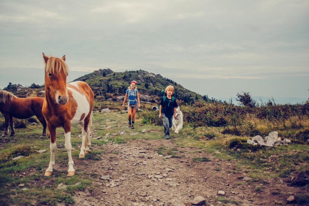 Photo Credit: Sam Dean, IG account: @sdeanphotos
Over a mile high, enjoy rock outcrops, meadows, spruce, ponies. From park to Massey Gap on Appalachian Trail for panoramas. Add camping, picnics.
After the Hike: Bike 17 miles downhill on Virginia Creeper Trail from Damascus.
NATURAL TUNNEL STATE PARK
Nearest Town: Duffield
Hike Distance: 1.8-mile out-and-back
Why Go There: Level trail to Natural Tunnel, creek views, Lovers Leap
What You Need to Know: Sky lift option to tunnel; other amenities
GPS Coordinates: 36.70219, -82.74565
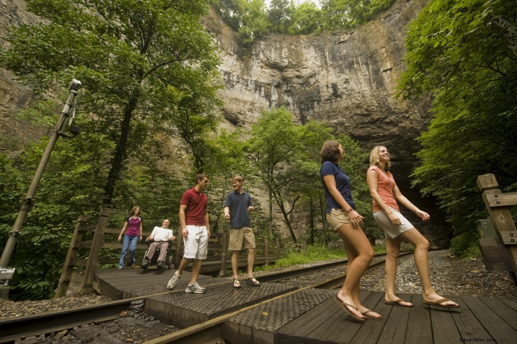 Photo Credit: Scott K. Brown
Follow Stock Creek to massive Natural Tunnel (railroad-routed), 220-year-old Carter Cabin, gorge rim views, Lovers Leap geology. Sky lift available (fee). Cave tours, camping.
After the Hike: Paddle Clinch River with local outfitters in St. Paul.