Top 10 Fall Camping Destinations in Virginia: Peak Foliage Adventures
For avid outdoor enthusiasts, fall is the ultimate season for camping in Virginia. As the first cool fronts sweep across the Allegheny Mountains, delivering crisp autumn air, tent and RV campers envision crackling campfires nestled deep in the woods, high in the mountains, along serene lakeshores, or beside the coast—immersed in the Old Dominion's stunning landscapes.
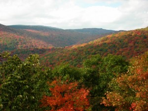
Virginia's extended autumn season maximizes camping opportunities. Foliage peaks in the western Appalachians by early October, progressing eastward through the Piedmont to the Atlantic coast, where colors linger into mid-November.
The secret to exceptional fall camping lies in choosing sites amid deciduous trees—red maples, yellow tulip poplars, orange oaks, and maroon sweetgums—where vibrant hues contrast beautifully, accented by evergreen pines.
And that signature Virginia fall aroma: sun-warmed drying leaves, cinnamon-spiced hot apple cider on crisp evenings, and lazy woodsmoke curls—it's an irresistible summons to the great outdoors!
Discover 10 premier Virginia fall camping spots, spanning elevations and regions from west to east. Experience the joy of pitching a tent or parking your RV amid autumn splendor. Each includes a recommended fall color hike. Sites are ordered by peak foliage timing.
GRAYSON HIGHLANDS STATE PARK
Nearest Town: Independence
Fall Color Peak: Early October to mid-October
What You Need to Know: Virginia's highest campground at 4,250 feet
GPS Coordinates: 36.62124, -81.48448

Fall arrives first on Virginia's rooftop. This elevated Grayson Highlands State Park campground delivers premium experiences for tent and RV campers amid dramatic foliage. Abundant trails offer vistas from rocky outcrops and cascading waterfalls, providing a peaceful escape from daily stresses.
Sites stretch through oak-maple forests, with a dedicated RV loop. Reservable campsites, bathhouses, scattered water spigots, and a dump station ensure convenience. The adjacent Country Store operates weekends.
Recommended Fall Color Walk: Hike the 1.6-mile Twin Pinnacles Trail to the park's highest point. It showcases diverse habitats, culminating in panoramic views from Little Pinnacle and Big Pinnacle before looping back to the visitor center.
WHITE ROCKS CAMPGROUND
Nearest Town: Pembroke
Fall Color Peak: Early-mid October to mid-late October
What You Need to Know: Pack all supplies—no nearby stores
GPS Coordinates: 37.43021, -80.49227
Deep in Jefferson National Forest, this spacious, wooded campground features level sites amid rolling hills. Water spigots are available, and it rarely fills, ensuring easy access. Oak-dominated woods deliver vibrant color right from your site, with hiking, scenic drives, the Appalachian Trail, and Wind Rock views nearby.
Recommended Fall Color Walk: The 1.3-mile "Virginias Walk" starts near site #9, loops into West Virginia and back, ending at site #26—a perfect stroll.
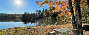
SHERANDO LAKE
Nearest Town: Sherando
Fall Color Peak: Early-mid October to end of October
What You Need to Know: Endless activities—plan an extended stay
GPS Coordinates: 37.91863, -79.01167
A standout in Washington National Forest, this well-maintained campground nestles in a picturesque valley under the Blue Ridge, enhanced by two lakes. Three loops offer reservable electric sites, non-electric, and first-come-first-served options, with ample space, hot showers, flush toilets, and water.
Autumn hues abound: stroll or paddle the lakes, drive the Blue Ridge Parkway, bike Mills Creek, or hike family-friendly trails to challenging Torry Ridge ascents.
Recommended Fall Color Walk: Climb the steep 0.5-mile path to Lookout Rock for sweeping color vistas, or opt for the easy 2-mile loop around Sherando Lake.
STONY FORK
Nearest Town: Wytheville
Fall Color Peak: Mid-October to early November
What You Need to Know: Features a natural, spring-fed swimming pool
GPS Coordinates: 37.01029, -81.18124
This Jefferson National Forest gem offers 54 reservable sites with hot showers, flush toilets, and water spigots. Options include electric/water, water-only, or primitive sites along East Fork Stony Fork. Forest shades surround you, with trails nearby and Big Walker Lookout Tower a short drive away.
Recommended Fall Color Walk: A 2-mile loop via Stony Fork Trail and Seven Sisters Trail through dense hardwoods.
CAMP ROOSEVELT
Nearest Town: Luray
Fall Color Peak: Mid-late October to early-mid November
What You Need to Know: Site of the nation's first Civilian Conservation Corps camp
GPS Coordinates: 38.73339, -78.51736
Between Massanutten and Kerns Mountains along Passage Creek, this 10-site Washington National Forest campground basks under oaks and hardwoods. Drinking water and flush toilets available (no showers). Nearby Shenandoah River forks invite colorful paddles; explore CCC history on-site.
Recommended Fall Color Walk: From VA 675 east of camp, ascend Massanutten Mountain Trail south via Duncan Hollow (part of a 71-mile loop).
DOUTHAT STATE PARK
Nearest Town: Clifton Forge
Fall Color Peak: Late October to early November
What You Need to Know: Renowned for waterfalls and overlooks
GPS Coordinates: 37.89676, -79.80226
One of Virginia's original six state parks and a National Historic District, developed by the CCC in the 1930s. Trails for hikers, bikers, and equestrians lead to the lake, waterfalls, and overlooks amid fiery foliage. Boat rentals available.
Varied camping: primitive lakeview sites, water/electric at White Oak and Whispering Pines, plus equestrian options. Park restaurant overlooks the shimmering lake.
Recommended Fall Color Walk: Trek to Lookout Rock and Tuscarora Overlook via Blue Suck Falls. Enjoy the restored CCC cabin and epic views of Wilson Creek and Beards Mountain.
PRINCE WILLIAM FOREST
Nearest Town: Dumfries
Fall Color Peak: Mid-late October to mid-November
What You Need to Know: Autumn views by car, bike, or foot in this D.C.-area preserve
GPS Coordinates: 38.55988, -77.36863

Over 15,000 acres of hardwood forests and pines near D.C. suburbs. Explore 37 miles of trails or Scenic Drive.
Oak Ridge Campground suits tents (100 sites in three loops; A first-come, B/C reservable) with showers, toilets, water. RVers: nearby full-hookup RV campground.
Recommended Fall Color Walk: 1-mile Farms to Forest Trail loop from Oak Ridge, plus Quantico Creek extension for varied terrain and colors.
BELLE ISLE STATE PARK
Nearest Town: Lively
Fall Color Peak: Late October to mid-November
What You Need to Know: Rentals: bikes, canoes, kayaks, motorboats
GPS Coordinates: 37.77689, -76.59794
Along 7 miles of Rappahannock River peninsula, with woods, fields, creeks, and trails on old farm roads. Multi-modal exploration: hike, bike, paddle, or boat.
Modern 28-site campground: all electric/water, hot showers, direct trail access via Campground Spur.
Recommended Fall Color Walk: Campground Spur to 1+ mile White Oak Swamp Loop through wooded wetlands.
BEAR CREEK LAKE STATE PARK
Nearest Town: Cumberland
Fall Color Peak: Late October to mid-November
What You Need to Know: 14-mile Cumberland Multi-use Trail
GPS Coordinates: 37.53096, -78.26999
In Cumberland State Forest by 40-acre Bear Creek Lake. Ideal for hiking, fishing, paddling, biking amid vivid woods.
Acorn Loop: primitive tent sites; Black Oak: water/electric for RVs; Chestnut: weekend pop-ups/small tents—all wooded.
Recommended Fall Color Walk: 1.8-mile Channel Cat Trail loop from camp along lake and woods; try multi-use trail by bike.
STAUNTON RIVER STATE PARK
Nearest Town: South Boston
Fall Color Peak: Late October to mid-late November
What You Need to Know: On Virginia's largest lake, Kerr Reservoir
GPS Coordinates: 36.7028, -78.66627

Fall colors mirror on 50,000+ acre Buggs Island Lake (800+ shoreline miles). Boat from launch, hike loops, stargaze as an International Dark Sky Park.
47 wooded sites: 14 RV electric/water, 20 electric/water for tents/pop-ups, 13 primitive; hot showers.
Recommended Fall Color Walk: 8.5-mile River Bank Trail along shores through hardwoods; highlights include Dan-Staunton confluence overlook.